Development Potential of 112,500 sf
Description
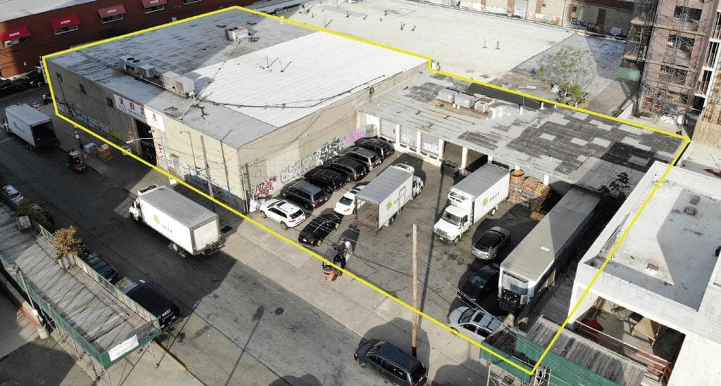
DY Realty Group, LLC has been retained on an exclusive basis to handle the disposition of 31-09 Starr Avenue & 52-24 34th Street in Long Island City, Queens.
31-09 Starr Avenue consists of a 14,600 sf 2-story building on a plot of 12,500 sf.
52-34 34th Street consists of an 4,000 sf building with a 4,000 sf lower level on a plot of 10,000 sf.
Combined, the site offers a total plot of 22,500 sf, and the zoning of M1-3 allows for an FAR of 5.0, totaling 112,500 buildable square feet.
Only one block from the Long Island Expressway and minutes from Manhattan, this industrial assemblage presents a rare opportunity to enter the hard sought Long Island City real estate market.
Documents
Location
Sq Ft
Financials
Construction
Image Gallery
Area Profile
Western Queens (LIC, Astoria, Maspeth, Woodside)
The Western Queens area, including neighborhoods like Long Island City, Maspeth, Astoria, & Woodside, has long been a significant industrial hub in Queens, known for its mix of manufacturing, warehousing, and distribution centers as well as its proximity to Manhattan. Despite residential rezoning along the waterfronts in Long Island City and Astoria, Western Queens still retains a substantial industrial presence and has further evolved into a major hub for the film and television industry.
Maspeth in particular has remained a predominantly industrial area. As the geographic center of New York City, is a strategic location for logistics, distribution and warehousing as well as heavy manufacturing.
Proximity to Major Highways: Strategically located near major highways such as the Long Island Expressway (I-495), Brooklyn-Queens Expressway (I-278), and Grand Central Parkway.
Access to Bridges and Tunnels: Convenient access to several key bridges and tunnels, including the Queensboro Bridge (59th Street Bridge), Triborough Bridge (Robert F. Kennedy Bridge), and Queens-Midtown Tunnel.
Public Transportation Hubs: Served by multiple subway lines (such as the 7, N, W, E, M, R) and bus routes, providing residents and workers with extensive public transportation options.
Proximity to Airports: Close to LaGuardia Airport, one of New York City's major airports, facilitating convenient access for businesses involved in logistics and transportation.
Zoning
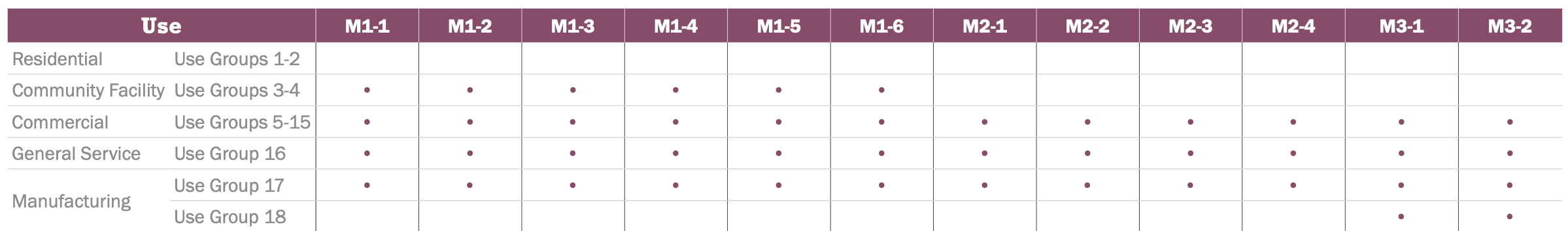
M1-3 Zone
M-zones are designed to accommodate a variety of industrial and manufacturing activities, including heavy and light manufacturing, warehousing, distribution centers, and storage facilities. These areas are regulated by zoning laws to ensure compatibility with surrounding neighborhoods and to manage issues such as noise, traffic, and environmental impacts.
Typical Uses
Typical uses include warehousing and storage, wholesale services, showrooms, media production, repair centers, etc.